莫霍特隆区
外观
| 莫霍特隆区 Mokhotlong District | |
|---|---|
| 区 | |
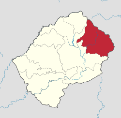
 Map of Lesotho with the district highlighted | |
| 坐标:29°20′00″S 29°00′00″E / 29.333333333333°S 29°E | |
| 国家 | |
| 首府 | 莫霍特隆 |
| 面积 | |
| • 总计 | 4,075 平方公里(1,573 平方英里) |
| 海拔 | 2,512[1] 公尺(8,242 英尺) |
| 人口(2016) | |
| • 总计 | 100,442人 |
| • 密度 | 24.6人/平方公里(63.8人/平方英里) |
| 时区 | CAT(UTC+2) |
| 电话区号 | +266 |
| HDI (2019) | 0.461[2] low · 9th |
莫霍特隆区(英语:Mokhotlong District)是莱索托东部的一个区。面积4,075平方公里。根据2006年人口普查统计,人口为95,332人。[3]首府莫霍特隆。
参考资料
[编辑]- ^ Unnamed Road, Lesotho. Elevationmap.net. [19 December 2018].
- ^ Sub-national HDI - Area Database - Global Data Lab. hdi.globaldatalab.org. [2018-09-13] (英语).
- ^ 2006 census. Lesotho Bureau of Statistics. [2008-04-15]. (原始内容存档于2011-07-22).
| 这是一篇与莱索托相关的小作品。您可以通过编辑或修订扩充其内容。 |
