布塔-布泰区
外观
| 布塔-布泰区 Butha-Buthe District | |
|---|---|
| 区 | |
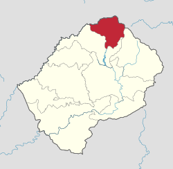
 Map of Lesotho with the district highlighted | |
| 坐标:28°50′00″S 28°30′00″E / 28.833333333333°S 28.5°E | |
| 国家 | |
| 首府 | 布塔-布泰 |
| 面积 | |
| • 总计 | 1,767 平方公里(682 平方英里) |
| 人口(2014) | |
| • 总计 | 118,242人 |
| • 密度 | 66.9人/平方公里(173人/平方英里) |
| 时区 | CAT(UTC+2) |
| 电话区号 | +266 |
| HDI (2019) | 0.536[1] low · 3rd |
布塔-布泰区(英语:Butha-Buthe District)是莱索托北部的一个区。面积1,767平方公里。根据2006年人口普查统计,人口为109,139人。[2]首府布塔-布泰。
气候
[编辑]| 布塔-布泰区 | |||||||||||||
|---|---|---|---|---|---|---|---|---|---|---|---|---|---|
| 月份 | 1月 | 2月 | 3月 | 4月 | 5月 | 6月 | 7月 | 8月 | 9月 | 10月 | 11月 | 12月 | 全年 |
| 平均高温 °C(°F) | 26 (79) |
26 (79) |
24 (75) |
21 (70) |
19 (66) |
16 (61) |
15 (59) |
20 (68) |
22 (72) |
26 (79) |
26 (79) |
27 (81) |
22 (72) |
| 平均低温 °C(°F) | 14 (57) |
14 (57) |
11 (52) |
5 (41) |
5 (41) |
1 (34) |
1 (34) |
6 (43) |
5 (41) |
11 (52) |
13 (55) |
14 (57) |
8 (47) |
| 平均降雨量 mm(英寸) | 186 (7.3) |
59 (2.3) |
79 (3.1) |
7 (0.3) |
60 (2.4) |
38 (1.5) |
0 (0) |
6 (0.2) |
0 (0) |
30 (1.2) |
181 (7.1) |
145 (5.7) |
792 (31.2) |
| 数据来源1:[3] | |||||||||||||
| 数据来源2:[4] | |||||||||||||
参考资料
[编辑]- ^ Sub-national HDI - Area Database - Global Data Lab. hdi.globaldatalab.org. [2018-09-13] (英语).
- ^ 2006 census. Lesotho Bureau of Statistics. [2008-04-15]. (原始内容存档于2008-08-28).
- ^ Lesotho Bureau of Statistics. Tables A.6c and A.7c, Botha-Bothe Station, Tables_A_Geography.xls, 2008.
- ^ Lesotho Bureau of Statistics. Table A.5c, Botha-Bothe Station, Tables_A_Geography.xls, 2008.
