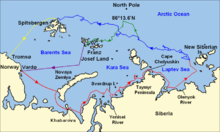
File:Nansen Fram Map.svg
外观

此SVG文件的PNG预览的大小:800 × 479像素。 其他分辨率:320 × 192像素 | 640 × 383像素 | 1,024 × 614像素 | 1,280 × 767像素 | 2,560 × 1,534像素 | 1,003 × 601像素。
原始文件 (SVG文件,尺寸为1,003 × 601像素,文件大小:183 KB)
文件历史
点击某个日期/时间查看对应时刻的文件。
| 日期/时间 | 缩略图 | 大小 | 用户 | 备注 | |
|---|---|---|---|---|---|
| 当前 | 2022年9月21日 (三) 16:21 |  | 1,003 × 601(183 KB) | Andrei Stroe | File uploaded using svgtranslate tool (https://svgtranslate.toolforge.org/). Added translation for ro. |
| 2018年9月15日 (六) 21:41 |  | 1,003 × 601(175 KB) | Jay D. Easy | Changed yellow line to gold (ffff00 to ffd7000) to allow for easier legibility when combined with <nowiki>{{legend-line}}</nowiki> in captions, since a yellow line on a white background is often hard to make out. | |
| 2009年10月16日 (五) 17:03 |  | 1,003 × 601(175 KB) | Beao | Tweak. | |
| 2009年10月16日 (五) 17:01 |  | 1,003 × 601(175 KB) | Beao | Tweak. | |
| 2009年10月16日 (五) 16:58 |  | 1,003 × 601(175 KB) | Beao | Removed flowRoot | |
| 2009年10月16日 (五) 16:49 |  | 1,003 × 601(190 KB) | Beao | Redrew lines and deleted link to image. | |
| 2009年10月16日 (五) 14:27 |  | 1,052 × 744(850 KB) | Ruhrfisch | == Summary == {{Information |Description = Map of the Arctic Ocean showing the routes taken during the 1893–96 Nansen's Fram expedition: {{legend|red|Frams's route eastward from Vardø to the Siberian coast, turning nort |
文件用途
以下2个页面使用本文件:
全域文件用途
以下其他wiki使用此文件:
- ca.wikipedia.org上的用途
- cs.wikipedia.org上的用途
- en.wikipedia.org上的用途
- it.wikipedia.org上的用途
- ja.wikipedia.org上的用途
- ka.wikipedia.org上的用途
- ro.wikipedia.org上的用途
- rue.wikipedia.org上的用途


