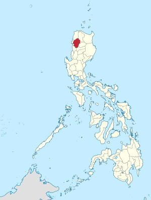
阿布拉省
| 阿布拉省 Abra | |
|---|---|
 在菲律宾的位置 | |
| 坐标:17°35′N 120°45′E / 17.58°N 120.75°E | |
| 国家 | 菲律宾 |
| 政域 | 科迪勒拉行政区 (CAR) |
| 建立于 | 1917年3月9日 |
| 首府 | 邦贵 |
| 政府 | |
| • 省长 | Eustaquio P. Bersamin (PDSP) |
| 面积 | |
| • 总计 | 3,975.6 平方公里(1,535.0 平方英里) |
| 面积排名 | 31st largest |
| 人口(2000年人口普查) | |
| • 总计 | 209,491人 |
| • 排名 | 12th smallest |
| • 密度 | 53人/平方公里(140人/平方英里) |
| • 密度排名 | 4th lowest |
| 区域 | |
| • 高度都市化城市 | 0 |
| • 组合城市 | 0 |
| • 自治市 | 27 |
| • 描笼涯 | 303 |
| • 议会区域 | Lone District of Abra |
| 时区 | 菲律宾标准时间(UTC+08:00) |
| IDD区码 | {{safesubst:#switch:area_code
| settlement_type = {{safesubst:#if:菲律宾省|
{{safesubst:#ifexpr:0| 自治市 (菲律宾)|
{{safesubst:#ifexpr:0| {{safesubst:|Cities of the Philippines| city|
}}
}}
}}
| nickname1 = | motto = | image_skyline = Abra Provincial Hall.JPG | image_caption = | image_flag = Vlag Fil Abra.gif | image_seal = | image_shield = | image_map = Abra in Philippines.svg | map_caption = Map of 科迪勒拉行政区 with 阿布拉省 highlighted | image_map1 = | map_caption1 = Map of 阿布拉省 showing barangays | official_name = Province of Abra | iso_region | iso_code | coordinates_region = PH-ABR | coord | coordinates = Template:PH wikidata/iso 17°35′N 120°45′E / 17.58°N 120.75°E | country = 菲律宾 | region = Template:PH wikidata/region | province = 科迪勒拉行政区 | district = Legislative district: 科迪勒拉行政区
| seat = 邦贵[*] | capital_of = | municipalities | barangays = 脚本错误:没有“sorted plain list”这个模块。 | established_date | founded = 10 3 1917 | founder = | leader_title | mayor_title = Governor of Abra[*] | vicemayor_title = Vice Governor of Abra | council_title = Council | elevation_m = P2044 | elevation_ft = P2044 | elevation_footnotes = | population_as_of = 错误:时间格式不正确 人口普查 | population_point_in_time = 错误:时间格式不正确 | population_total = 250,985 | household = 58,956 | household_point_in_time = 错误:时间格式不正确 | poverty_incidence = 15.80 | poverty_incidence_point_in_time = 2021 | poverty_incidence_footnotes = [1] | electorate_title = Voter Template:PH Comelec roll | electorate = 182,696 | electorate_point_in_time = 错误:时间格式不正确 | language = Banao Itneg、Binongan Itneg、Northern Kankanay、Moyadan Itneg、Isnag、Iraya、Adasen、Villa Viciosa Agta、Inlaod Itneg、Maeng Itneg、Masadiit Itneg、Mabaka Valley Kalinga | area = 4,165.25 | population_demonym | demonym = | postal_code = | located_on | located_in = | area_code = +63 (0)74 | income_class | income_class_text = 3rd provincial income class | electoral_district = 第Abra's at-large congressional district届 | number_of_divisions = | short name = | timezone = PST | utc_offset = +08:00 |income_class_title = 收入等级 |income_class_ordinal = 3rd class | psgc_title = PSGC | psgc = 140100000 | icao = | iata = | diocese = | patron_saint = | website = www | facebook = @AbraProvince2017 | twitter = @ | instagram = @ | youtube = @ | commons = Abra (province) | name = 阿布拉省 | settlement_text = | government_type =
| revenue_point_in_time = (2012年) | assets = 1,265,149,430.18 菲律宾披索 | assets_point_in_time = (2012年) | liabilities = 480,950,436.42 菲律宾披索 | liabilities_point_in_time = (2012年) | expenditure = 428,654,401.42 菲律宾披索 | expenditure_point_in_time = (2012年) | osm = 52299 | climate_title = 气候类型 | climate_type = 热带雨林气候 | operator = | has_part = | hdi = | hdi_point_in_time = ?
| #default = Template:PH wikidata/deprecated parameter Template:PH wikidata called with unsupported input "area_code" }} |
| 语言 | Ilokano, Tingguian/Itneg |
阿布拉省(英文:Abra Province)是菲律宾吕宋岛科迪勒拉行政区的一个内陆省份,成立于1917年,人口约20万(2000年),首府邦贵。
外部链接
[编辑]| 这是一篇与菲律宾相关的小作品。您可以通过编辑或修订扩充其内容。 |
- ^ 2021 Full Year Official Poverty Statistics of the Philippines (PDF). 菲律宾统计局. 2022年8月15日 [2024年4月28日].

