格林尼治村
外观
(重定向自Greenwich Village)
| 格林尼治村 | |
|---|---|
| 曼哈顿境内地区 | |
 格林尼治村心脏的华盛顿广场公园 | |
 纽约市内的位置 | |
| 坐标:40°44′02″N 74°00′07″W / 40.734°N 74.002°W | |
| 国家 | |
| 州 | |
| 城市 | |
| 行政区 | 曼哈顿 |
| 社区 | 曼哈顿第二区[1] |
| 语源 | Groenwijck (绿区) |
| 面积[2] | |
| • 总计 | 0.7 平方公里(0.289 平方英里) |
| 人口[2] | |
| • 总计 | 22,785人 |
| 居民称谓 | Villager |
| 经济[2] | |
| • 中位户年所得 | $119,728 USD |
| 时区 | Eastern(UTC−5) |
| • 夏时制 | EDT(UTC−4) |
| ZIP Codes | 10003, 10011, 10012, 10014[2] |
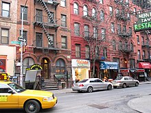
格林尼治村(英语:Greenwich Village)是纽约市曼哈顿南部下西城的一个大型居住区,大部分居民为中产阶级家庭,但在19世纪后期和20世纪上中叶却以波希米亚主义首都和垮掉的一代诞生地著称。具有讽刺意味的是,该区最初吸引人的那些特征最终导致其走向中产阶级化和商业化[3][4]。
格林尼治村得名于荷兰语 "Groenwijck",意即“绿色区域”。
范围
[编辑]格林尼治村东到百老汇大道,西到哈德孙河,南到豪斯顿街,北到14街。周边街区为:东面是东村,南面是SoHo,北面是切尔西。东村属于下东城,与格林尼治村无关[5]。西村是格林尼治村第七大道以西的部分,但是房地产经纪人则说是第六大道以西的部分。该街区属于纽约第八选区。

参考文献
[编辑]- ^ NYC Planning | Community Profiles. communityprofiles.planning.nyc.gov. New York City Department of City Planning. [March 18, 2019]. (原始内容存档于2021-12-27).
- ^ 2.0 2.1 2.2 2.3 Greenwich Village neighborhood in New York. [March 18, 2019]. (原始内容存档于2021-09-17).
- ^ Costic, Robert S. Is gentrification good for the poor?. Perspectives (American Jurist). 2004-04-29 [2007-12-02]. (原始内容存档于2016-12-20).
- ^ Strenberg, Adam, Embers of Gentrification, New York Magazine, 2007-11-12: 5 [2009-04-16], (原始内容存档于2020-05-30)
- ^ F.Y.I. (页面存档备份,存于互联网档案馆), "When did the East Village become the East Village and stop being part of the Lower East Side?", Jesse McKinley, New York Times, June 1, 1995; accessed August 26, 2008.
外部链接
[编辑]- Greenwich Village Society for Historic Preservation (页面存档备份,存于互联网档案馆)
- Village Voice (页面存档备份,存于互联网档案馆)
- Official Tourist map (controversially showing Greenwich Village to include the East Village (页面存档备份,存于互联网档案馆)
- Greenwich Village Historic District (页面存档备份,存于互联网档案馆) - map from the New York City Landmarks Preservation Commission
- Greenwich Village (页面存档备份,存于互联网档案馆), by Anna Alice Chapin, 1919, from Project Gutenberg
