沃楚西特礁
外观
| 沃楚西特礁 | |
|---|---|
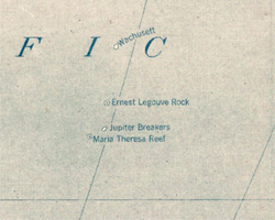
 1921年太平洋地图上的沃楚西特礁 | |
| 虚构设定信息 | |
| 类型 | 幽灵岛 |
| 知名地点 | 太平洋 |


沃楚西特礁(Wachusett Reef)是由“沃楚西特”号的船长兰伯特(Lambert)所回报,在1899年6月4日他穿过了一个暗礁,似乎是由珊瑚礁组成,大约位于32°18′S 151°08′W / 32.300°S 151.133°W。该暗礁似乎有500英尺宽。礁石的底部两侧呈现深灰色与深蓝色。深度估计约在5至6㖊之间,不幸的是没有探测资料[1]。
2005年的“国家地理世界地图集”仍有画出沃楚西特礁,深度是9米[2]。然而,它的存在令人怀疑。其他历史上曾经被回报过的附近的暗礁包括埃内斯特·勒古韦礁、木星礁以及玛丽亚·特里萨礁。
参考文献
[编辑]- ^ United States Hydrographic Office. Pacific Islands Pilot, v. 2. Washington, D.C.: Government Printing Office. 1916: 56 [2011-09-26]. (原始内容存档于2014-07-07).
- ^ National Geographic Atlas of the World, 8th edition (2005). Washington, D.C.: National Geographic, plate 93. ISBN 0-7922-7543-8
- Eade, J.V. (1976). Geological notes on the Southwest Pacific Basin in the area of Wachusett Reef and Maria Theresa Reef. Wellington: New Zealand Oceanographic Institute.
| 这是一篇与海洋相关的小作品。您可以通过编辑或修订扩充其内容。 |
