
File:Maldives.visibleearth.nasa.jpg

預覽大小:466 × 599 像素。 其他解析度:187 × 240 像素 | 373 × 480 像素 | 597 × 768 像素 | 796 × 1,024 像素 | 1,400 × 1,800 像素。
原始檔案 (1,400 × 1,800 像素,檔案大小:530 KB,MIME 類型:image/jpeg)

|
This map has been uploaded by Electionworld from en.wikipedia.org to enable the |
摘要
Source: http://visibleearth.nasa.gov archive copy at the Wayback Machine
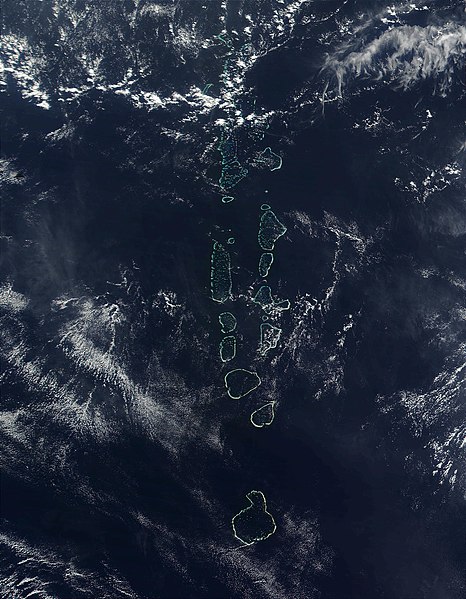
It should be noted that the southern most Atoll of the Maldives, Addu Atoll, is not visible on this image.
授權條款
| 本作品由NASA創作,屬於公有領域。根據NASA的版權政策:“NASA的創作除非另有聲明否則不受版權保護。”(參見:Template:PD-USGov/zh,NASA版權政策或JPL圖像使用政策) | ||
 |
警告:
|
檔案歷史
點選日期/時間以檢視該時間的檔案版本。
| 日期/時間 | 縮圖 | 尺寸 | 使用者 | 備註 | |
|---|---|---|---|---|---|
| 目前 | 2006年11月27日 (一) 22:52 | | 1,400 × 1,800(530 KB) | Electionworld | {{ew|en|Oblivious}} == Summary == '''Source:''' [http://veimages.gsfc.nasa.gov/2686/Maldives.A2002090.0525.500m.jpg http://visibleearth.nasa.gov] It should be noted that the southern most Atoll of the Maldives, Addu Atoll, is not visible on this ima |
檔案用途
下列頁面有用到此檔案:
全域檔案使用狀況
以下其他 wiki 使用了這個檔案:
- af.wikipedia.org 的使用狀況
- ar.wikipedia.org 的使用狀況
- en.wikipedia.org 的使用狀況
- gl.wikipedia.org 的使用狀況
- hi.wikipedia.org 的使用狀況
- it.wikipedia.org 的使用狀況
- kn.wikipedia.org 的使用狀況
- lt.wikipedia.org 的使用狀況
- mk.wikipedia.org 的使用狀況
- ml.wikipedia.org 的使用狀況
- my.wikipedia.org 的使用狀況
- pl.wikipedia.org 的使用狀況
- ps.wikipedia.org 的使用狀況
- sd.wikipedia.org 的使用狀況
- sr.wikipedia.org 的使用狀況
- ta.wikipedia.org 的使用狀況
- th.wikipedia.org 的使用狀況
- trv.wikipedia.org 的使用狀況
- tr.wikipedia.org 的使用狀況
- uk.wikipedia.org 的使用狀況
- vi.wikipedia.org 的使用狀況