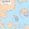
File:Cebuairportmap.png
外觀

預覽大小:600 × 599 像素。 其他解析度:240 × 240 像素 | 481 × 480 像素 | 769 × 768 像素 | 1,025 × 1,024 像素 | 2,363 × 2,360 像素。
原始檔案 (2,363 × 2,360 像素,檔案大小:420 KB,MIME 類型:image/png)
檔案歷史
點選日期/時間以檢視該時間的檔案版本。
| 日期/時間 | 縮圖 | 尺寸 | 使用者 | 備註 | |
|---|---|---|---|---|---|
| 目前 | 2013年1月21日 (一) 01:06 |  | 2,363 × 2,360(420 KB) | Kmusser | updated destinations |
| 2011年1月27日 (四) 23:29 |  | 1,000 × 1,000(438 KB) | Kmusser | Updated destinations | |
| 2009年1月6日 (二) 19:56 |  | 1,000 × 1,000(412 KB) | Kmusser | typo fix | |
| 2009年1月6日 (二) 19:44 |  | 1,000 × 1,000(412 KB) | Kmusser | Updated destinations | |
| 2008年1月3日 (四) 15:43 |  | 1,000 × 1,000(302 KB) | Kmusser | {{Information |Description=This is a route map for Mactan-Cebu International Airport as of January 2008. Map is an Azimuthal equidistant projection centered on the airport |
檔案用途
下列頁面有用到此檔案:
全域檔案使用狀況
以下其他 wiki 使用了這個檔案:
- ceb.wikipedia.org 的使用狀況
- en.wikipedia.org 的使用狀況
- id.wikipedia.org 的使用狀況
- vi.wikipedia.org 的使用狀況

