跳转到内容

File:Shrinking Lake Ebinur 2013.jpg

页面内容不支持其他语言。
这个文件来自维基共享资源
维基百科,自由的百科全书

原始文件 (5,593 × 3,729像素,文件大小:6.86 MB,MIME类型:image/jpeg


摘要

描述
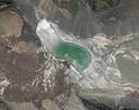
English: In 2014, the eastern lobe of the Aral Sea dried up, bringing attention to the human impact on the Central Asian landscape. But the Aral Sea isn’t the only lake in the region that is losing water. In northwestern China, near the border of Kazakhstan, Lake Ebinur has shrunk by 50 percent since 1955.

The Operational Land Imager (OLI) on Landsat 8 captured this image of Lake Ebinur (also called Aibi or Ebi lake) on October 20, 2013. The lake’s saline water appears light blue, while the dried lake bed, or playa, is white. Largely surrounded by mountains, Ebinur Lake sits at the bottom of a drainage basin with no outlet. The Borohoro Mountains lie to the south and the Dzungarain Alatau mountains lie to the north. Farms and settlements in the Boertala Valley are visible west of the lake.

Lake Ebinur’s size fluctuates from year to year due natural variations in snowmelt and rainfall. But human activity has played a key role in drawing down the lake over the past five decades, according to research published by scientists from the Chinese Academy of Sciences. The middle inset shows Bole, a bustling city of 425,000 people in the Boertala Valley that consumes significant amounts of water. Farmers in the valley (especially cotton farmers) also irrigate their crops with water that would otherwise go into the lake.

The drawdown of Lake Ebinur has exposed broad playas that are rich with salt and other minerals left behind when pools of water evaporate. Winds rush through a gap in the mountains to the north—the Dzungarian Gate—and regularly kick up saline dust storms on the playa. That salty dust is often carried east into the Junggar Basin.

In the bottom inset, note the sand dunes and the role that wind has played in sculpting the playa. Frequent dust storms have a range of undesirable effects downwind. For instance, saline dust contributes to desertification, damages soils, harms wetlands, and may be hastening the melting of snow and glaciers downwind.
日期
来源 https://earthobservatory.nasa.gov/images/84785/shrinking-lake-ebinur
作者 NASA Earth Observatory image by Robert Simmon and Adam Voiland, using Landsat data from the U.S. Geological Survey. Caption by Adam Voiland.
其他版本

许可协议

Public domain 本文件完全由NASA创作,在美国属于公有领域。根据NASA的版权方针,NASA的材料除非另有声明否则不受版权保护。(参见Template:PD-USGov/zhNASA版权方针页面JPL图片使用方针。)
警告:
Public domain
本图片在美国属于公有领域,因为其只包含最初来自美国内政部下属机构美国地质调查局的材料。更多信息请参见USGS官方版权方针

Bahasa Indonesia  català  čeština  Deutsch  eesti  English  español  français  galego  italiano  Nederlands  português  polski  sicilianu  suomi  Tiếng Việt  Türkçe  български  македонски  русский  മലയാളം  한국어  日本語  中文  中文(简体)  中文(繁體)  العربية  فارسی  +/−

说明

添加一行文字以描述该文件所表现的内容

此文件中描述的项目

描绘内容

版权状态 简体中文(已转写)

文件历史

点击某个日期/时间查看对应时刻的文件。

日期/时间缩⁠略⁠图大小用户备注
当前2022年2月12日 (六) 07:462022年2月12日 (六) 07:46版本的缩略图5,593 × 3,729(6.86 MB)Hubert KororoUploaded a work by NASA Earth Observatory image by Robert Simmon and Adam Voiland, using Landsat data from the U.S. Geological Survey. Caption by Adam Voiland. from https://earthobservatory.nasa.gov/images/84785/shrinking-lake-ebinur with UploadWizard

没有页面使用本文件。

元数据