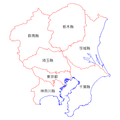
File:Kanto Region Administration Map TC.png
外觀
Kanto_Region_Administration_Map_TC.png (600 × 600 像素,檔案大小:42 KB,MIME 類型:image/png)
檔案歷史
點選日期/時間以檢視該時間的檔案版本。
| 日期/時間 | 縮圖 | 尺寸 | 用戶 | 備註 | |
|---|---|---|---|---|---|
| 目前 | 2007年1月15日 (一) 13:10 |  | 600 × 600(42 KB) | Taiwan Junior | {{Information |Description=日本關東地方行政區圖 |Source=自行繪製 |Date=2007.1.15 |Author=台灣少年 |Permission= |other_versions= }} |
檔案用途
下列頁面有用到此檔案:


