跳至內容

File:EastJerusalemMap-es.svg

頁面內容不支援其他語言。
這個檔案來自維基共享資源
維基百科,自由的百科全書

原始檔案 (SVG 檔案,表面大小:384 × 589 像素,檔案大小:88 KB)


描述

[編輯]

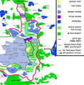
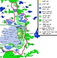
Deutsch: Karte Jerusalems:
 
Westjerusalem und Skopusberg
 
Waffenstillstandslinie von 1949
 
Altstadt
 
Arabische Viertel in Ostjerusalem
 
Stadtgrenze bis 1967
 
Jüdische Viertel in Ostjerusalem
 
Stadtgrenze
 
Jüdische Gebiete im Westjordanland
 
Arabische Gebiete im Westjordanland
English: Map of Jerusalem:
 
West Jerusalem and Mount Scopus
 
1949 armistice line
 
Old City, fully annexed by Israel
 
East Jerusalem, occupied Arab areas, annexed by Israel
 
Pre-1967 municipal boundary
 
East Jerusalem, Jewish areas, annexed by Israel
 
Current Israeli extended boundary of the municipality and of the district of Jerusalem
 
West Bank, Jewish areas in the new district of Samaria and Judea (zone C)
 
West Bank, occupied Arab areas (zone A, partially controled by the Palestinian National Authority)
Español: Mapa de Jerusalén:
 
Jerusalén Oeste y Monte Scopus
 
Frontera de armisticio de 1949
 
Ciudad Vieja
 
Jerusalén Este, áreas árabes
 
Frontera anterior a 1967
 
Jerusalén Este, áreas judías
 
Frontera de Jerusalén
 
Cisjordania, áreas judías
 
Cisjordania, áreas árabes
Français : Carte de Jérusalem :
 
Jérusalem-Ouest et Mont Scopus
 
Ligne d'armistice de 1949
 
Vieille ville, entièrement annexée par Israël
 
Jérusalem-Est, secteurs arabes occupés par Israël
 
Frontière municipale avant 1967
 
Jérusalem-Est, territoires juives annexées par Israël après 1967
 
Frontière actuelle d'extension israélienne de la municipalité et du district de Jérusalem
 
Cisjordanie, territoires juives dans le nouveau district israélien de Samarie et de Judée (zone C)
 
Cisjordanie, secteurs arabes occupés (zone A, partiellement contrôlée par l'Autorité nationale palestinienne)
日期
來源
圖片提取流程
本檔案提取自另一個檔案
:​EastJerusalemMap.jpg
原始檔案
作者 Doron, Chabacano
授權許可
(重用此檔案)
GNU head 已授權您依據自由軟體基金會發行的無固定段落、封面文字和封底文字GNU自由文件授權條款1.2版或任意後續版本,對本檔進行複製、傳播和/或修改。該協議的副本列在GNU自由文件授權條款中。
w:zh:創用CC
姓名標示 相同方式分享
此檔案採用創用CC 姓名標示-相同方式分享 3.0 未在地化版本授權條款。
您可以自由:
  • 分享 – 複製、發佈和傳播本作品
  • 重新修改 – 創作演繹作品
惟需遵照下列條件:
  • 姓名標示 – 您必須指名出正確的製作者,和提供授權條款的連結,以及表示是否有對內容上做出變更。您可以用任何合理的方式來行動,但不得以任何方式表明授權條款是對您許可或是由您所使用。
  • 相同方式分享 – 如果您利用本素材進行再混合、轉換或創作,您必須基於如同原先的相同或兼容的條款,來分布您的貢獻成品。
已新增授權條款標題至此檔案,作為GFDL授權更新的一部份。
其他版本

[編輯]

註解
InfoField
該圖片含有註解:在維基媒體共享資源上查看註解

說明

添加單行說明來描述出檔案所代表的內容

在此檔案描寫的項目

描繪內容

image/svg+xml

檔案歷史

點選日期/時間以檢視該時間的檔案版本。

日期/時間縮⁠圖尺寸使用者備⁠註
目前2009年8月1日 (六) 00:55於 2009年8月1日 (六) 00:55 版本的縮圖384 × 589(88 KB)Kordastranslated names
2007年6月26日 (二) 18:31於 2007年6月26日 (二) 18:31 版本的縮圖384 × 589(87 KB)Ignacio Icke
2007年6月11日 (一) 20:42於 2007年6月11日 (一) 20:42 版本的縮圖384 × 589(86 KB)Ignacio Icke{{Information |Description=Mapa de Jerusalén este: {{legend|#ac9f7f|Casco antiguo}} {{legend|#aebbe3|Jerusalén oeste}}{{legend|#5f8af6|Jerusalén este}}{{legend|#0049ee|West bank, áreas judías}}{{legend|#67f96c|Jerusalén este, áreas árabes}}{{legen

沒有使用此檔案的頁面。

全域檔案使用狀況

以下其他 wiki 使用了這個檔案:

檢視此檔案的更多全域使用狀況

詮釋資料