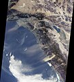
File:Santa Ana winds - satellite image.jpg
外观

本预览的尺寸:518 × 599像素。 其他分辨率:207 × 240像素 | 415 × 480像素 | 664 × 768像素 | 885 × 1,024像素 | 1,470 × 1,701像素。
原始文件 (1,470 × 1,701像素,文件大小:327 KB,MIME类型:image/jpeg)
文件历史
点击某个日期/时间查看对应时刻的文件。
| 日期/时间 | 缩略图 | 大小 | 用户 | 备注 | |
|---|---|---|---|---|---|
| 当前 | 2005年12月10日 (六) 17:52 |  | 1,470 × 1,701(327 KB) | Saperaud~commonswiki | cropped |
| 2005年9月3日 (六) 06:10 |  | 1,684 × 1,860(321 KB) | Epolk | The Santa Ana winds in Southern California sweep down across the deserts and across the Los Angeles Basin pushing dust far out into the Pacific Ocean. Courtesy NASA/JPL-Caltech |
文件用途
以下页面使用本文件:
全域文件用途
以下其他wiki使用此文件:
- ar.wikipedia.org上的用途
- bg.wikipedia.org上的用途
- bh.wikipedia.org上的用途
- bn.wikipedia.org上的用途
- ca.wikipedia.org上的用途
- cs.wikinews.org上的用途
- de.wikipedia.org上的用途
- en.wikipedia.org上的用途
- en.wikinews.org上的用途
- en.wikiversity.org上的用途
- en.wiktionary.org上的用途
- es.wikipedia.org上的用途
- eu.wikipedia.org上的用途
- fa.wikipedia.org上的用途
- fr.wikipedia.org上的用途
- Utilisateur:Mandariine
- Vent de Santa Ana
- Utilisateur:GhosterBot/BacASable/Le saviez-vous ?/Archives
- Wikipédia:Le saviez-vous ?/Archives/2023
- Discussion:Vent catabatique
- Wikipédia:Statistiques des anecdotes de la page d'accueil/Visibilité des anecdotes (2023)
- Discussion:Vent catabatique/LSV 21993
- Wikipédia:Statistiques des anecdotes de la page d'accueil/Visibilité des anecdotes (2023)/2023 02
- Projet:Aide et accueil/Twitter/Tweets/archives/février 2023
- Wikipédia:Wikimag/2023/9
- fr.wiktionary.org上的用途
- he.wikipedia.org上的用途
- hi.wikipedia.org上的用途
- id.wikipedia.org上的用途
- it.wikipedia.org上的用途
- ja.wikipedia.org上的用途
- ko.wikipedia.org上的用途
- ks.wikipedia.org上的用途
- ku.wikipedia.org上的用途
- mk.wikipedia.org上的用途
- ms.wikipedia.org上的用途
- nn.wikipedia.org上的用途
- pl.wikipedia.org上的用途
- ru.wikipedia.org上的用途
- tr.wikipedia.org上的用途
- www.wikidata.org上的用途


