跳转到内容

File:Nova totius Terrarum Orbis geographica ac hydrographica tabula (Hendrik Hondius) balanced.jpg

页面内容不支持其他语言。
这个文件来自维基共享资源
维基百科,自由的百科全书

原始文件 (5,248 × 3,688像素,文件大小:5.3 MB,MIME类型:image/jpeg


摘要

Jodocus Hondius II:​Nova totius terrarum orbis geographica ac hydrographica tabula  wikidata:Q120597485 reasonator:Q120597485
艺术家
Jodocus Hondius II  (1593–1629)  wikidata:Q21016928
 
描述 荷兰雕刻师、​制图师、​编辑、​instrument maker、​medical instrument maker和版画家
出生/逝世日期 1593年11月 在维基数据编辑 1629年8月 在维基数据编辑
出生/逝世地点 阿姆斯特丹 在维基数据编辑 阿姆斯特丹 在维基数据编辑
工作地点
阿姆斯特丹 (1612年–1633年) 在维基数据编辑
规范控制
creator QS:P170,Q21016928
 在维基数据编辑
image of artwork listed in title parameter on this page
作者
亨里克斯·洪第乌斯二世  (1597–1651)  wikidata:Q983261
 
其他姓名
Hendrick Hondius, Henricus Hondius II, Hendrik Hondius the Younger
描述 西班牙-荷兰制图师、​出版人、​版画家、​画家和书商
出生/逝世日期 1597年 在维基数据编辑 1651年8月16日 在维基数据编辑
出生/逝世地点 阿姆斯特丹 在维基数据编辑 阿姆斯特丹 在维基数据编辑
工作时期 1612年 在维基数据编辑–1644年 在维基数据编辑
工作地点
规范控制
creator QS:P170,Q983261
标题
拉丁语:
Nova Totius Terrarum Orbis Geographica ac Hydrographica Tabula

New Geographic and Hydrographic Map of the Whole World
title QS:P1476,la:"Nova Totius Terrarum Orbis Geographica ac Hydrographica Tabula"
label QS:Lla,"Nova Totius Terrarum Orbis Geographica ac Hydrographica Tabula"
label QS:Len,"New Geographic and Hydrographic Map of the Whole World"
出版者
物体类型 世界地图 / antique map / manuscript map / double hemisphere world map / 早期世界地图 在维基数据编辑
艺术类型 地图 在维基数据编辑
描述

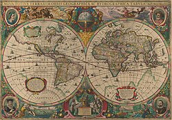
This is an image of Nova totius Terrarum Orbis geographica ac hydrographica tabula, a map of the world created by Hendrik Hondius in 1630, and published the following year in the atlas Atlantis Maioris Appendix.

Among its claims to notability is the fact that it was the first dated map published in an atlas, and therefore the first widely available map, to show any part of Australia, the only previous map to do so being Hessel Gerritsz' 1627 Caert van't Landt van d'Eendracht ("Chart of the Land of Eendracht"), which was not widely distributed.

The Australian coastline shown is part of the west coast of Cape York Peninsula, discovered by Jan Carstensz in 1623. Curiously, the map does not show the west coast features shown in Gerritsz' Caert.
语言 拉丁语 在维基数据编辑
日期 The original map was executed in 1630, and published in 1631.
出版日期 1630年 在维基数据编辑
尺寸 高度:​54厘米 在维基数据编辑;宽度:​38厘米 在维基数据编辑
dimensions QS:P2048,+54U174728
dimensions QS:P2049,+38U174728
institution QS:P195,Q111677119
出版地 未知 在维基数据编辑
来源/摄影师 This is a scan of the copy belonging to the State Library of New South Wales. Access to it is available at http://image.sl.nsw.gov.au/cgi-bin/ebindshow.pl?doc=heritage/a1439;seq=13. The graphical user interface provided does not support downloading the full image at full resolution, but the back end can be cajoled to do so by manually editing the CGI arguments in the url, to http://image.sl.nsw.gov.au/cgi-bin/mrsid/image_jpeg.pl?client=heritage/a1439&image=a128994.sid&x=2624&y=1844&level=0&width=5248&height=3688.
其他版本 This is a colour-balanced version; the original version is at Image:Nova totius Terrarum Orbis geographica ac hydrographica tabula (Hendrik Hondius).jpg

许可协议

这是一个平面公有领域艺术品的忠实摄影副本。原艺术品本身因为下列原因属于公有领域:
Public domain

本作品在其来源国以及其他著作权期限是作者逝世后100年或以下的国家和地区属于公有领域


你必须增加美国公有领域标签显示为何这个作品在美国属于公有领域。
本文件已被确认为免除已知的著作权法限制(包括所有相关权利)。
维基媒体基金会的官方立场认为:“对平面公有领域艺术品的忠实再制作品也属于公有领域。”
因此,可以认为此摄影副本在美国也属于公有领域。在其他司法管辖区,再利用此内容可能存在限制;参见再利用PD-Art照片了解详细信息。

说明

添加一行文字以描述该文件所表现的内容
Early Double Hemisphere World Map.

此文件中描述的项目

描绘内容

世界地图 简体中文(已转写)

文件历史

点击某个日期/时间查看对应时刻的文件。

日期/时间缩⁠略⁠图大小用户备注
当前2008年2月6日 (三) 23:092008年2月6日 (三) 23:09版本的缩略图5,248 × 3,688(5.3 MB)Hesperian{{Information |Description=This is an image of ''Nova totius Terrarum Orbis geographica ac hydrographica tabula'', a map of the world created by Hendrik Hondius in 1630, and published the following year in the atlas ''Atlantis Maioris Appendix

以下页面使用本文件:

全域文件用途

以下其他wiki使用此文件:

查看此文件的更多全域用途

元数据