
File:Madaba map.jpg

本预览的尺寸:800 × 561像素。 其他分辨率:320 × 224像素 | 640 × 449像素 | 1,024 × 718像素。
原始文件 (1,024 × 718像素,文件大小:193 KB,MIME类型:image/jpeg)
摘要
| 描述 |
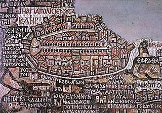
Deutsch: Darstellung Jerusalems auf der Mosaikkarte von Madaba
English: Jerusalem as seen on the Madaba Map
Español: Mosaico de Mandaba del siglo VI. Mosaico realizado circa 570 para decorar el suelo de una iglesia bizantina en Mandaba, Jordania. Muestra la región de Jordania y Palestina al norte y Egipto al sur, e incluye un plano de Jerusalén en el que se aprecia a la izquierda la puerta norte, de la que parte el Cardus Maximus en dirección sur. El mapa se encuentra en la iglesia ortodoxa de San Jorge, construída en 1896 sobre los restos de la Iglesia bizantina original, aunque solo se conserva un fragmento. Originalmente medía 25 x 5 metros. |
| 日期 | |
| 来源 | W:en:Image:Madaba_map.jpg http://www.mcah.columbia.edu/dbcourses/islamic/large/madaba_map.jpg |
| 作者 | 未知 |
|
本作品在其来源国以及其他著作权期限是作者逝世后100年或以下的国家和地区属于公有领域。 | |
| 本文件已被确认为免除已知的著作权法限制(包括所有相关权利)。 | |
文件历史
点击某个日期/时间查看对应时刻的文件。
| 日期/时间 | 缩略图 | 大小 | 用户 | 备注 | |
|---|---|---|---|---|---|
| 当前 | 2008年2月7日 (四) 13:28 | | 1,024 × 718(193 KB) | Gusgus | {{Information |Description=Madaba map, plano de Jerusalén del siglo VI. |Source=http://en.wikipedia.org/wiki/Image:Madaba_map.jpg |Date=7 de febrero de 2008 |Author=User:Gusgus |other_versions= }} {{PD-old}} Category:Ancient Roman forts |
文件用途
以下页面使用本文件:
全域文件用途
以下其他wiki使用此文件:
- ar.wikipedia.org上的用途
- arz.wikipedia.org上的用途
- az.wikipedia.org上的用途
- be.wikipedia.org上的用途
- bg.wikipedia.org上的用途
- bs.wikipedia.org上的用途
- ca.wikipedia.org上的用途
- cs.wikipedia.org上的用途
- de.wikipedia.org上的用途
- de.wikiquote.org上的用途
- el.wikipedia.org上的用途
- en.wikipedia.org上的用途
- Aelia Capitolina
- Mosaic
- Timeline of Jerusalem
- History of Jerusalem
- Around the World in 80 Treasures
- Madaba Map
- Portal:Jordan
- Tourism in Jordan
- Early Byzantine mosaics in the Middle East
- Timeline of the Palestine region
- Gerasimus I of Jerusalem
- Cartography of Jerusalem
- Tel Hadid
- Draft:Outline of Jerusalem
- en.wikivoyage.org上的用途
- eo.wikipedia.org上的用途
- es.wikipedia.org上的用途
查看此文件的更多全域用途。