
File:MSH80 mudline muddy river with USGS scientist 10-23-80.jpg

本预览的尺寸:800 × 536像素。 其他分辨率:320 × 215像素 | 640 × 429像素 | 1,024 × 687像素 | 1,280 × 858像素 | 2,904 × 1,947像素。
原始文件 (2,904 × 1,947像素,文件大小:2.64 MB,MIME类型:image/jpeg)
摘要
| 描述 |
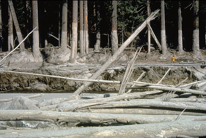
English: (copied description from USGS site): Nearly 135 miles (220 kilometers) of river channels surrounding the volcano [Mt. St. Helens] were affected by the lahars of May 18, 1980. A mudline left behind on trees shows depths reached by the mud. A scientist (middle right) gives scale. This view is along the Muddy River, southeast of Mount St. Helens. |
| 日期 | 摄于1980年10月23日 |
| 来源 | http://vulcan.wr.usgs.gov/Glossary/Lahars/description_lahars.html |
| 作者 | Lyn Topinka, USGS |
许可协议
|
|
文件历史
点击某个日期/时间查看对应时刻的文件。
| 日期/时间 | 缩略图 | 大小 | 用户 | 备注 | |
|---|---|---|---|---|---|
| 当前 | 2022年12月12日 (一) 03:35 | | 2,904 × 1,947(2.64 MB) | Hike395 | less jpeg compression, re-crop from original |
| 2011年10月10日 (一) 02:32 |  | 2,916 × 1,948(1.21 MB) | Materialscientist | crop frame | |
| 2010年9月2日 (四) 15:02 |  | 3,072 × 2,048(4.07 MB) | Awickert | {{Information |Description={{en|1=(copied description from USGS site): Nearly 135 miles (220 kilometers) of river channels surrounding the volcano [Mt. St. Helens] were affected by the lahars of May 18, 1980. A mudline left behind on trees shows depths re |
文件用途
以下页面使用本文件:
全域文件用途
以下其他wiki使用此文件:
- bg.wikipedia.org上的用途
- bn.wikipedia.org上的用途
- ceb.wikipedia.org上的用途
- cs.wikipedia.org上的用途
- de.wikipedia.org上的用途
- en.wikipedia.org上的用途
- es.wikipedia.org上的用途
- fr.wikipedia.org上的用途
- he.wikipedia.org上的用途
- id.wikipedia.org上的用途
- it.wikipedia.org上的用途
- nl.wikipedia.org上的用途
- oc.wikipedia.org上的用途
- ro.wikipedia.org上的用途
- sk.wikipedia.org上的用途
- sv.wikipedia.org上的用途
- tr.wikipedia.org上的用途
- uk.wikipedia.org上的用途
- vi.wikipedia.org上的用途
- www.wikidata.org上的用途