
File:CookANZ.JPG
此为最大尺寸。
CookANZ.JPG (237 × 154像素,文件大小:10 KB,MIME类型:image/jpeg)

|
此historical map图片可使用矢量图形重新创建为SVG文件。这具有很多好处;更多信息请参见共享资源:待清理媒体。如果存在此图片的SVG格式,请将其上传,然后将此模板替换为
{{vector version available|新图片名称}}。
建议您将SVG命名为“CookANZ.svg”,这样在使用Vector version available(或Vva)模板时就不需要填写新图片名称参数。 |


| 描述 |
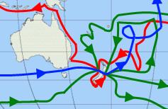
English: Map showing the three voyages of Captain James Cook proximate to Australia and New Zealand, with the first version in red, second in green, and third in blue. |
| 日期 | (UTC) |
| 来源 | |
| 作者 |
|
| 这是一张修改过的图片,这意味着它已在原版本的基础上通过软件进行了编辑,改动内容:Focused on Australia and NZ。其原始版本为:Cook Three Voyages 59.png。修改者:Tasbian。
|
我,本作品著作权人,特此采用以下许可协议发表本作品:
本文件采用知识共享署名-相同方式共享 3.0 未本地化版本许可协议授权。
- 您可以自由地:
- 共享 – 复制、发行并传播本作品
- 修改 – 改编作品
- 惟须遵守下列条件:
- 署名 – 您必须对作品进行署名,提供授权条款的链接,并说明是否对原始内容进行了更改。您可以用任何合理的方式来署名,但不得以任何方式表明许可人认可您或您的使用。
- 相同方式共享 – 如果您再混合、转换或者基于本作品进行创作,您必须以与原先许可协议相同或相兼容的许可协议分发您贡献的作品。

|
已授权您依据自由软件基金会发行的无固定段落及封面封底文字(Invariant Sections, Front-Cover Texts, and Back-Cover Texts)的GNU自由文件许可协议1.2版或任意后续版本的条款,复制、传播和/或修改本文件。该协议的副本请见“GNU Free Documentation License”。 |
您可以选择您需要的许可协议。
原始上传日志
This image is a derivative work of the following images:
- File:Cook_Three_Voyages_59.png licensed with Cc-by-sa-3.0, GFDL
- 2010-02-17T22:19:34Z AlexiusHoratius 800x401 (275844 Bytes) Made Nootka Sound landing more obvious, corrected Atlantic routes for first voyage.
- 2009-05-27T04:35:44Z AlexiusHoratius 800x401 (274764 Bytes) Made lines and arrows a bit cleaner, corrected some lines near the map's edge, background now transparent
- 2008-07-25T09:43:47Z Urdangaray 800x401 (247890 Bytes) {{Information |Description={{en|Map showing the three voyages of Captain James Cook, with the first version in red, second in green, and third in blue. The route of Cook's crew following his death is shown as a dashed blue li
Uploaded with derivativeFX
文件历史
点击某个日期/时间查看对应时刻的文件。
| 日期/时间 | 缩略图 | 大小 | 用户 | 备注 | |
|---|---|---|---|---|---|
| 当前 | 2010年3月24日 (三) 04:51 | | 237 × 154(10 KB) | Tasbian | {{Information |Description={{en|Map showing the three voyages of Captain James Cook proximate to Australia and New Zealand, with the first version in red, second in green, and third in blue.}} |Source=*File:Cook_Three_Voyages_59.png |Date=2010-03-24 |
文件用途
以下页面使用本文件:
全域文件用途
以下其他wiki使用此文件:
- en.wikipedia.org上的用途
- it.wikipedia.org上的用途