
File:Chicxulub radar topography.jpg
本预览的尺寸:536 × 599像素。 其他分辨率:215 × 240像素 | 429 × 480像素 | 715 × 799像素。
原始文件 (715 × 799像素,文件大小:119 KB,MIME类型:image/jpeg)
摘要
| 描述 |
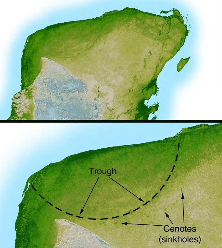
English: This shaded relief image of Mexico's Yucatan Peninsula show a subtle, but unmistakable, indication of the Chicxulub impact crater. Most scientists now agree that this impact was the cause of the Cretatious-Tertiary Extinction, the event approximately 66 million years ago that marked the sudden extinction of the dinosaurs as well as the majority of life then on Earth. |
| 日期 | |
| 来源 | http://photojournal.jpl.nasa.gov/catalog/PIA03379 |
| 作者 | NASA/JPL-Caltech |
| 其他版本 | version with more labels and scale indicators |
| 此标签不表示文件的著作权状态。任何文件在附有此标签的同時还需要一个有效的著作权标签。请参阅许可协议说明页面以了解更多信息。 其他语言:
|
许可协议
| 本文件完全由NASA创作,在美国属于公有领域。根据NASA的版权方针,NASA的材料除非另有声明否则不受版权保护。(参见Template:PD-USGov/zh、NASA版权方针页面或JPL图片使用方针。) | ||
 |
警告:
|
文件历史
点击某个日期/时间查看对应时刻的文件。
| 日期/时间 | 缩略图 | 大小 | 用户 | 备注 | |
|---|---|---|---|---|---|
| 当前 | 2005年9月11日 (日) 04:38 | | 715 × 799(119 KB) | Miya | This image is originally uploaded to English Wikipedia with the informaion as follows: [[{{PD}}Radar topography]] (color corresponds to height) of the [[{{PD}}Yucatán]] peninsula, revealing the en:Chicxulub Crater. Courtesy NASA/JPL-Caltech (it is |
文件用途
以下2个页面使用本文件:
全域文件用途
以下其他wiki使用此文件:
- ar.wikipedia.org上的用途
- ast.wikipedia.org上的用途
- br.wikipedia.org上的用途
- ca.wikipedia.org上的用途
- da.wikipedia.org上的用途
- en.wikipedia.org上的用途
- es.wikipedia.org上的用途
- fr.wikipedia.org上的用途
- hu.wikipedia.org上的用途
- it.wikipedia.org上的用途
- ja.wikipedia.org上的用途
- lt.wikipedia.org上的用途
- lv.wikipedia.org上的用途
- mk.wikipedia.org上的用途
- nl.wikipedia.org上的用途
- oc.wikipedia.org上的用途
- pl.wikipedia.org上的用途
- pt.wikipedia.org上的用途
- su.wikipedia.org上的用途
- te.wikipedia.org上的用途
- vi.wikipedia.org上的用途