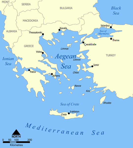
File:Aegean Sea map.png
外观
Aegean_Sea_map.png (540 × 599像素,文件大小:170 KB,MIME类型:image/png)
文件历史
点击某个日期/时间查看对应时刻的文件。
| 日期/时间 | 缩略图 | 大小 | 用户 | 备注 | |
|---|---|---|---|---|---|
| 当前 | 2014年3月17日 (一) 03:36 |  | 540 × 599(170 KB) | Ahmet Gürsakal | I arranged the new cities |
| 2014年3月17日 (一) 03:00 |  | 540 × 599(170 KB) | Ahmet Gürsakal | 2 new cities added | |
| 2010年6月15日 (二) 18:56 |  | 1,480 × 1,642(408 KB) | Ras67 | cropped | |
| 2010年6月15日 (二) 13:20 |  | 1,500 × 1,662(531 KB) | Kintetsubuffalo | POV naming of Macedonia against WPMOS | |
| 2007年4月18日 (三) 11:13 |  | 1,500 × 1,662(531 KB) | Malakas | ||
| 2007年4月8日 (日) 00:47 |  | 1,500 × 1,662(531 KB) | Hoshie | labeled Montenegro. Under same lic. as original. | |
| 2006年1月12日 (四) 16:38 |  | 1,500 × 1,662(603 KB) | NormanEinstein | This map shows the location of the Aegean Sea between Greece and Turkey. Created by NormanEinstein, January 12, 2006. {{GFDL-self}} Category:Maps of seas |
文件用途
全域文件用途
以下其他wiki使用此文件:
- af.wikipedia.org上的用途
- ar.wikipedia.org上的用途
- azb.wikipedia.org上的用途
- az.wikipedia.org上的用途
- ba.wikipedia.org上的用途
- be.wikipedia.org上的用途
- bg.wikipedia.org上的用途
- bh.wikipedia.org上的用途
- br.wikipedia.org上的用途
- bs.wikipedia.org上的用途
- ca.wikipedia.org上的用途
- ce.wikipedia.org上的用途
- ckb.wikipedia.org上的用途
- cs.wikipedia.org上的用途
- da.wikipedia.org上的用途
- en.wikipedia.org上的用途
- en.wikinews.org上的用途
- en.wikiquote.org上的用途
- fa.wikipedia.org上的用途
- he.wikipedia.org上的用途
- hi.wikipedia.org上的用途
- hyw.wikipedia.org上的用途
- id.wikipedia.org上的用途
- id.wikibooks.org上的用途
- incubator.wikimedia.org上的用途
- is.wikipedia.org上的用途
- it.wikipedia.org上的用途
- ja.wikipedia.org上的用途
- ka.wikipedia.org上的用途
- ko.wikipedia.org上的用途
- lt.wikipedia.org上的用途
- mhr.wikipedia.org上的用途
- ml.wikipedia.org上的用途
- mr.wikipedia.org上的用途
查看此文件的更多全域用途。


