跳至內容

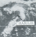
File:CharlieSep191972.png

頁面內容不支援其他語言。
這個檔案來自維基共享資源
維基百科,自由的百科全書

CharlieSep191972.png (334 × 349 像素,檔案大小:110 KB,MIME 類型:image/png


摘要

描述
English: This weather satellite image of the forming Subtropical Storm Charlie was taken on September 19, 1972.
日期
來源 Mariners Weather Log, July 1973, pg. 206
作者 NOAA
拍攝地點37° 30′ 00″ 北, 58° 00′ 00″ 西 Kartographer map based on OpenStreetMap.位於此地的本圖片與其他圖片: OpenStreetMapinfo

授權條款

Public domain
本圖像屬於公有領域,因該作品最初來自於美國國家海洋和大氣管理局職員的職務作品。

العربية  čeština  Deutsch  Zazaki  English  español  eesti  suomi  français  hrvatski  magyar  italiano  日本語  한국어  македонски  മലയാളം  Plattdüütsch  Nederlands  polski  português  română  русский  sicilianu  slovenščina  Türkçe  Tiếng Việt  简体中文  繁體中文  +/−

原始上傳日誌

日期/時間 尺寸 使用者 備⁠註
2013年4月1日, 03:54:17 334 × 349 (113891 bytes) Thegreatdr (留言 · 貢獻) User created page with UploadWizard

說明

添加單行說明來描述出檔案所代表的內容

在此檔案描寫的項目

描繪內容

視角坐標 繁體中文 (已轉換拼寫)

38°N, 58°W

37ee3b5bd327e75fd267c3051f7995394c99a86b

斷定方法:​SHA-1 中文 (已轉換拼寫)

112,737 位元組

349 像素

334 像素

檔案歷史

點選日期/時間以檢視該時間的檔案版本。

日期/時間縮⁠圖尺寸使用者備⁠註
目前2014年11月21日 (五) 10:57於 2014年11月21日 (五) 10:57 版本的縮圖334 × 349(110 KB)GifTaggerBot: Converting file to superior PNG file. (Source: CharlieSep191972.gif). This GIF was problematic due to non-greyscale color table.

下列頁面有用到此檔案:

全域檔案使用狀況

以下其他 wiki 使用了這個檔案: